Ah, the many facets of professional driving. There is an immense difference between cruising along an open and expansive interstate with lush, welcoming scenery versus sandwiching a less-than-petite commercial vehicle into a busy city’s congested, rush-hour traffic.
On the road, our locations often alter our level of comfort and safety. In trucking and transportation, hazardous areas present a significant risk to professional drivers and fleet operations. Due to the associated issues related to dangerous locations, drivers are more likely to exhibit high-risk driving behaviors in these areas.
Only the most adventurous drivers would consider continuing along a perilous career path that doesn’t prioritize their protection. Hazardous locations can lead to increased insurance premiums and reduced driver retention.
I constructed a database of dangerous locations using a predictive model and third-party data to gain comprehensive insights around hazardous areas for commercial drivers in the U.S. Here’s what I discovered!
Our database of hazardous locations
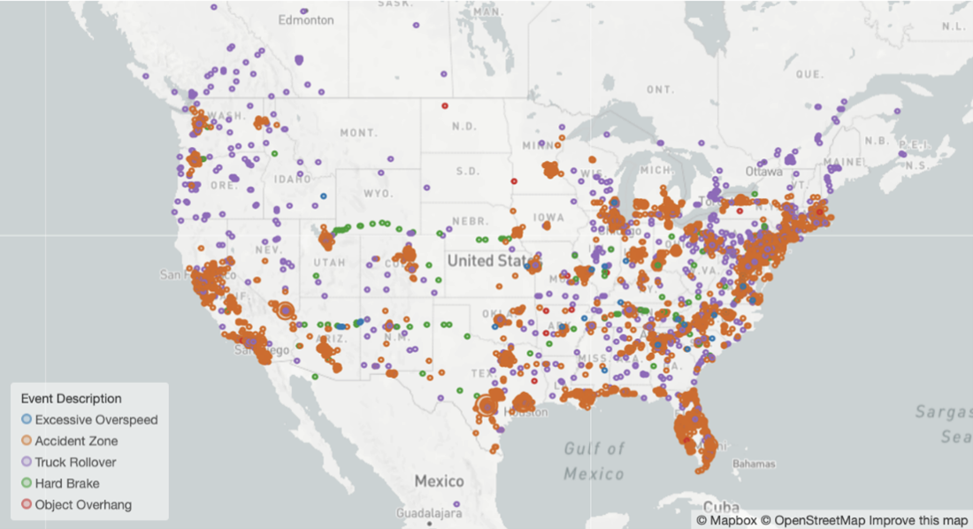
I classified high-risk areas as places where accidents or critical events, such as lane departures and hard braking, occur. Below is a dotted map view of hazardous locations across the country for truck route planning. Florida, Texas, and a significant portion of the mid to upper-East Coast bear the burden of hazardous driving factors.
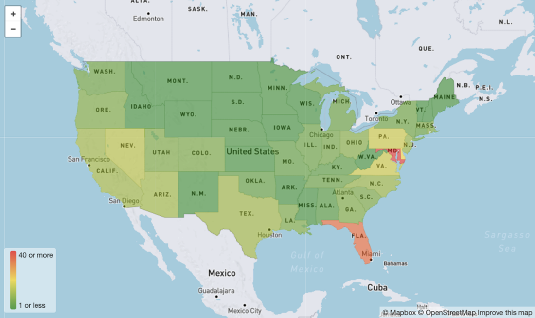
Further, we can see a heatmap breakdown of the number of hazardous locations per 1,000 state road miles below. I used the total miles of roadway in each state to configure these points, allowing me to see the actual density of these locations.
Maryland has approximately 40 or more hazardous locations per 1,000 state road miles, which is unsurprising given the state’s dotted breakdown and small density. Florida comes in second, and other East Coast states trail behind, with Nevada filling the highest Western U.S. slot.
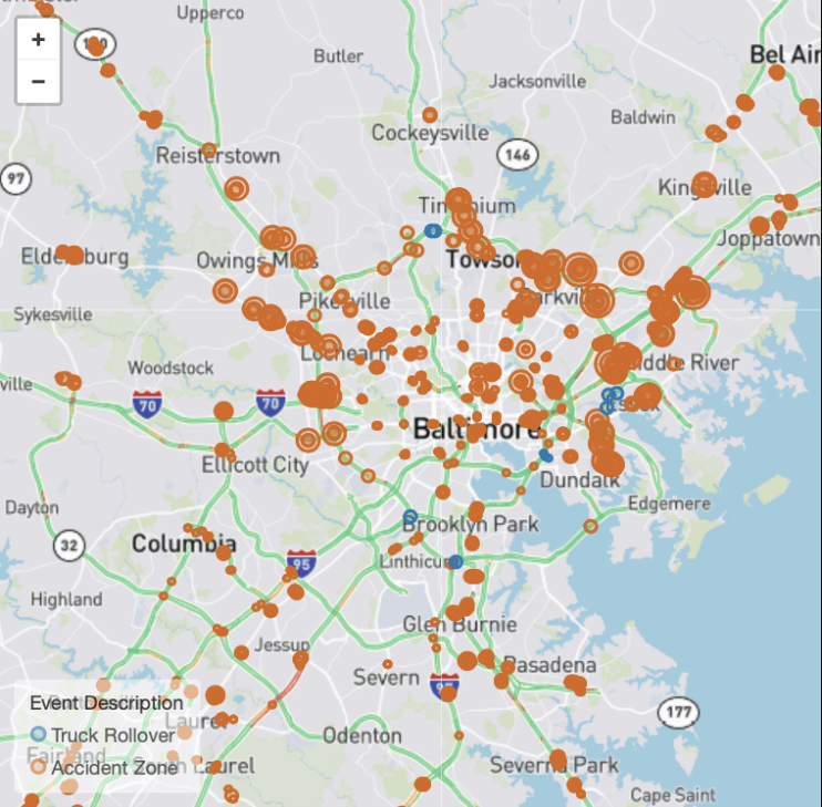
When we zoom in on the dotted map, we see that Maryland has the highest density of hazardous locations per roadway, which is shown below. The Baltimore area has 876 locations, almost all of which are accident zones. This density can be difficult for fleet monitoring, which is why having a strong fleet safety solution is place is crucial.
The correlation between accidents and locations
One-half of the top ten trucking accident factors can be tied to location. These factors include:
- Traffic flow interruption and congestion
- Traveling too fast for conditions
- Unfamiliarity with roadways
- Roadway problems
- Missing required stops
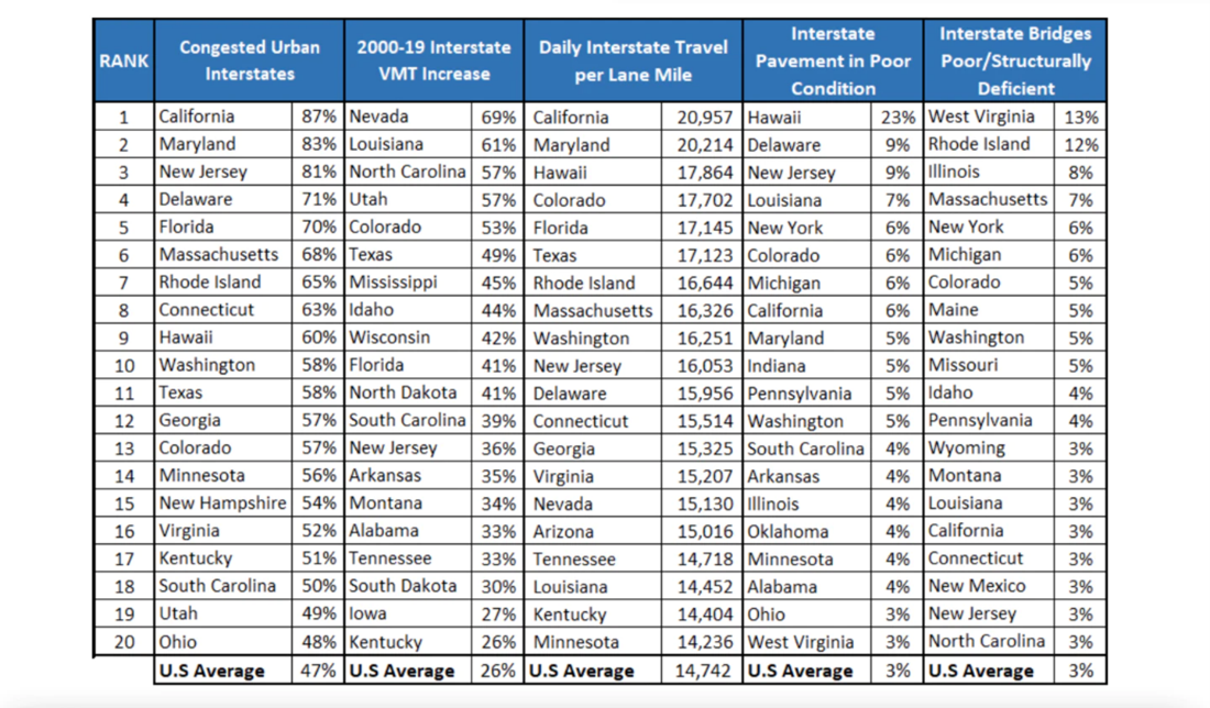
TRIP, a national transportation research group, released this 2021 breakdown of the states with the worst-ranked traffic and highways. California tops the list of congested urban interstates, while Nevada holds the number one spot with the most significant increase in vehicle miles of travel (VMT). California also holds the highest ranking for the most daily interstate travel per lane mile. Hawaii has the largest share of pavement in poor condition, and West Virginia has the most significant share of bridges in poor and structurally deficient condition. Comparatively, this chart aligns with the hazardous location data in our map above.
Using Video-Based Safety technology to ensure drivers are always safe — even in the riskiest states
The data presented can enhance your safety culture, and it’s not intended to inflate your unease. While insights like these are quite eye-opening, you can still protect your fleet drivers regardless of which state they’re frequenting.
Transform your culture of safety with the latest in industry-leading intelligence, ensuring drivers and route operations are safe and protected every mile of their trip. Our hazardous locations database is live and available via an application programming interface (API). Add enhanced video-based safety technology solutions that fit your safety needs and goals to prevent collisions and gain insights into how safely drivers are driving, proactively alerting drivers before these behaviors lead to accidents. You can also add GPS technology to your fleet to ensure drivers are always on the safest, least-congested roadways.
I’ll be back with additional data dives for your operation soon! Keep up with the latest topics on the Omnitracs Road Ahead Blog.


